
 |
|
|
Aerial
- North Section (9.8 Mg) |
|
|
Aerial
- Middle Section (16.9 Mg) Buffalo Road to Louisville (156th Street, near Middle Creek) - some in Sarpy County and some in Cass County |
|
|
Aerial
- South Section (14.4 Mg) |
|
|
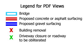
The
PDF Aerial View Files are large; please allow time for download. They will open in a new browser window to enable you to view the Legend above while you look at the maps |
|
An informational open house on this project was held on August 5, 2003, in Louisville, NE, to provide opportunity for the public to comment. The information available at that time is presented on these web pages. Some changes to the concept are likely to be made based on public input and further study. Another Public Information Meeting will be held, in 2004.
Brief Description: This project involves widening Highway 50 from Springfield south through Louisville and then transitioning back to the existing two-lane highway south of the (south) N-66 junction.
Extent of Project: South N-66 junction, Cass County, to Platteview Road, Sarpy County. Approximate highway reference posts from 74+20 to 82+93, approximately 8.5 miles. There is a short segment at Springfield that is already a four-lane segment and will remain a four-lane segment.
Purpose and Need: because of traffic increases on this two-lane highway, the purpose of the project is increase traffic capacity, and safety, by widening to a four-lane highway. Average daily traffic volumes are 7,715 for the year 2002 and are projected to be 12,380 for year 2027, which warrants a four-lane facility.
Current construction schedule: Sometime during the next five to ten years the project will be built. This could change depending upon availability of funding and other factors. Project to the North – To Be Constructed First: Springfield North, STPD-50-2(126), CN 21790, widening to four lanes is scheduled for construction in the next two to three years. Beginning near Highway 370, the project will widen Highway 50 to four lanes approximately to highway reference post 82+93, tying into the existing four-lane section just north of Platteview Road.
Under the Concept displayed at the August 5, 2003 Public Information Meeting . . .
- Existing alignment is followed except for a 0.8-mile stretch just north of the Platte River.
- Right-of-way property acquisition and temporary easements will be required along the entire project for construction and utility relocation. Nine (9) residences and five (5) business buildings are expected to be purchased.
- Some driveway accesses may be closed, or consolidated with nearby driveways.
- In some locations the highway may be flattened or re-graded to improve driver sight distance.
- The highway may be higher through Louisville, by approximately two feet.
- The project will be constructed under traffic, with at least one lane of traffic open in each direction for most of the duration.
- There will be several intersection modifications/relocations – see the attached display.
- Bridges will be constructed over BNSF Railway tracks (Louisville yard), Mill Creek, Platte River South Channel, Platte River North Channel (bridge widening, south abutment relocation), and Buffalo Creek.
- Wetlands will be affected, the major impacts being near the Platte River.
- Endangered species are present such as: Interior
Least Tern, Piping Plovers, Sturgeon Chub and Pallid Sturgeon.
| Jim Wilkinson Planning & Project Development Division Nebraska Department of Roads 1500 Highway 2 Lincoln, NE, 68509 402-479-4421 e-mail: jwilkins@dor.state.ne.us |
Steve McBeth Planning & Project Development Division Nebraska Department of Roads 1500 Highway 2 Lincoln, NE, 68509 402-479-4417 e-mail: smcbeth@dor.state.ne.us |
Top
of Page
Today
is: